AEROSPACE TECHNOLOGIES
Your browser is not supported.
For the best experience, please access this site using the latest version of the following browsers:
By closing this window you acknowledge that your experience on this website may be degraded.
HGuide o480 Navigator: High Performance Meets Low SWAP-C
HGuide o480 Navigator: High Performance Meets Low SWAP-C
The old saying that ‘conflict drives technology’ has never felt truer than in Ukraine.
Today’s battlefield underscores the importance of resilient navigation for autonomous and low-cost platforms like unmanned aerial vehicles (UAVs) used for intelligence, surveillance and reconnaissance (ISR), loitering munitions or unmanned ground vehicles.
Extending the reach of warfighters and enabling the remote control of multiple assets is a true force multiplier. However, this autonomy hinges on reliable navigation, even when global navigation satellite system (GNSS) signals are jammed or spoofed.
That’s the driving force behind Honeywell’s latest inertial navigation system INS/GNSS innovation, the HGuide o480 INS/GNSS Navigator, which sets new standards for high performance in a low SWaP-C (size, weight, power and cost) package.
Smaller than a business card and weighing only 26 grams, the HGuide o480 is available today at a price point ideal for attritable military assets and a wide range of industrial applications.
How the HGuide o480 Powers Resilient Navigation
As with all Honeywell INS/GNSS Navigators, the navigation software blends data from the onboard IMU and a Septentrio GNSS receiver to give the users accurate position, attitude and timing information. The AIM+ anti-jamming technology allows the system to continue operating even in the presence of moderate GNSS jamming.
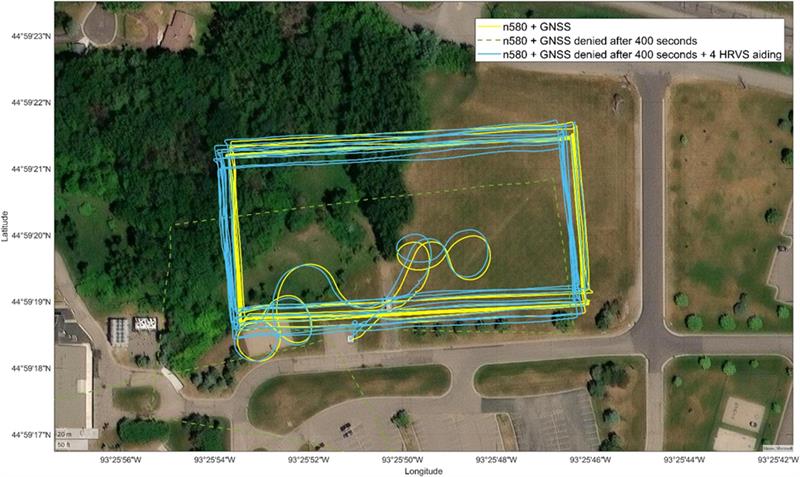
If GNSS jamming persists, the system continues to navigate using only the onboard IMU, which is sufficient for short outages. During extended GNSS outages, however, position and heading errors gradually accumulate due to the SWaP-C versus performance constraints on the IMU. Adding platform-appropriate navigation aids can significantly reduce this GNSS-denied position error, strengthening navigation resilience when GNSS is unavailable.
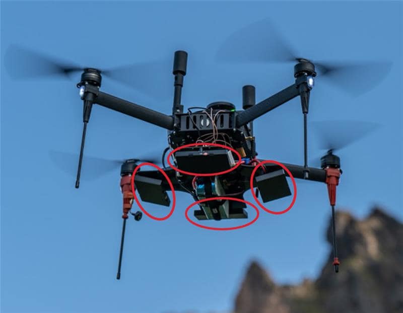
Aids may include velocity data from wheel/gearbox mounted sensors, the Honeywell Radar Velocity System (HRVS) True Ground Speed Sensor or a heading sensor such as a Honeywell magnetometer.
The o480 is also able to accept input from higher grade Honeywell IMUs, such as the no-license-required HGuide HG4930, where higher performance is required.
Staying on Course: Reliable Performance Without GNSS
With these aiding sources, land, aerial, and even marine platforms can navigate reliably over long distances without GNSS—and with minimal position error. In fact, initial testing shows both land and aerial platforms achieving gross errors of less than 0.5% of total distance traveled.
Historically, there has been a chase for ever-higher accuracy for “fire and forget” ordnance. However, the rise of AI and visual targeting means the onboard navigation system is now primarily needed to bring a platform within visual range, at which point the video or AI system takes over, following operator approval. The positioning performance of the o480, with or without GNSS, is more than capable to support mission success.
Designed and built in the EU, the HGuide o480 is available globally without export license restrictions and ready for rapid deployment and scalable production.
For more information on Honeywell HGuide INS technology, visit us online or email us at HGuide.sales@honeywell.com
