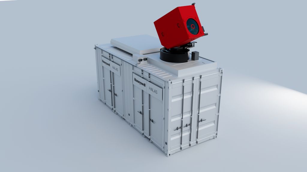
HALAS


Honeywell’s lidar technology can deliver near real-time, high-altitude, high-resolution atmospheric data, up to and beyond 30km in altitude. This enables faster, location-relevant atmospheric intelligence for safer launches, more accurate forecasts, and better-informed decisions across aerospace, defense, and climate-sensitive industries.
HALAS applications include:
Meteorology / Commercial Weather: For meteorologists, emergency planners and weather solutions providers seeking improved accuracy, HALAS provides near real-time atmospheric data through a connected network of devices. HALAS enables observations at a cadence tailored to your needs, providing more measurements of the atmospheric envelope at the times, locations and frequency you require. This results in better planning and more accurate forecasting.
Space Launches: For launch facilities and spaceports that need to stay on schedule and minimize delays from marginal weather conditions, HALAS technology delivers near real-time atmospheric data to support go/no-go decisions. With HALAS, you can maintain schedules, increase launch frequency and make confident decisions knowing you have the latest weather information at your fingertips.
Hypersonics / Missile Test: With near-real-time, location-specific atmospheric data beyond 30km, developers and designers can optimize each test by understanding the impact of atmospheric conditions on the tested device. This leads to increased test cadence, lower costs, improved results and faster development cycles.
Space Reentry: For mission planners requiring accurate atmospheric data for go/no-go decisions and last-minute adjustments, HALAS delivers near real-time high-altitude atmospheric readings exactly when and where they’re needed. HALAS ensures the precision necessary for mission success, especially during the critical phase of reentry.
Rocket Landing & Recovery: When a precise landing at a specific location is critical, and every minute counts, HALAS provides near real-time atmospheric awareness for your landing site. With HALAS, your operations team and decision-makers gain the reliable, location-specific data they need when timing is critical.
Unmanned High-Altitude Flight: High-altitude, slow-moving airships, balloons, and fixed-wing aircraft are highly sensitive to winds and atmospheric conditions at all altitudes. With HALAS data, you gain up-to-the-minute atmospheric insights, enabling real-time course planning and adjustments.
Additional capabilities including aerosol measurement, optical turbulence and gas sensing, will be added in the future.
Specifications
Dimensions
- 20 ft L x 8.5 ft W x 11 ft H
- Deployed Height: 18 ft
Weight
- 24,000 lbs.
Key Benefits
- Altitude: Measurements up to 80 km for some data products
- Available Data Products: Wind, Speed & Direction, Temperature, Humidity, Density, Cloud Height, Wind Shear... And more
- Current Draw: 100 A max, <40 A typical>
- Data Formats: .bfr, .csv, .txt, .sh2, .sh4, custom formats available
- Data-As-A-Service, no capital expenditure. Get the data you need without the responsibility and cost of asset ownership.
- Location Relevant: Measures atmosphere in area of interest, at time of interest
- Operations: Fully remote operation capabilities when human access is limited or dangerous
- Precision: Steerable laser provides measurement focal points to meet your requirements
- Reduced Waste: Compared to traditional weather balloon methods
- Secure Communications: Satcom, serial, ethernet, and cellular options
- Services: Data-As-A-Service and Equipment Purchase options available
- Transportable: Set up in (1) one day, tear down in (1) one day. (permanent installation options for long-term observations)
- Voltage: 208 V / 3 PH

